
Below is correspondence from Kathie Hightower which summarizes the latest information on the Summit Development.
Dave Williams
Neahkahnie Community Club Secretary
Here is the latest on the Summit development, an ODOT report from Marc Johnson and a summary by Mark Roberts of the latest NWD meeting with the developer and the Hydrogeologist present.
Marc Johnson is working to schedule a public meeting in future on this topic. Stay tuned. Kathie
1. ODOT:
My only contribution is to report that ODOT will be reviewing the
development of the project and formally commenting to Tillamook County
when an application is filed, but the agency has already determined that
the access points to the area are legal – in fact date back to the 1940s –
and that the traffic impacts fall outside their minimums to require any
specific mitigation. The estimated vehicle trips per day for the project,
for example, are 300 – ten trips per day per home – and that falls outside
the minimum needed to maintain a left turn lane for instance. As the ODOT
contact said: the Oregon Legislature some time back made it easier for
developers to peruse this type of project without a lot of ODOT review.
2. Neahkahnie Water District Meeting report:
Marc Johnson and I attended the regularly scheduled Neahkahnie Water District Board meeting Tuesday night.
Two special speakers at the meeting brought the proposed development
surrounding the NWD spring area adjacent to Neahkahnie Mountain up to
date.
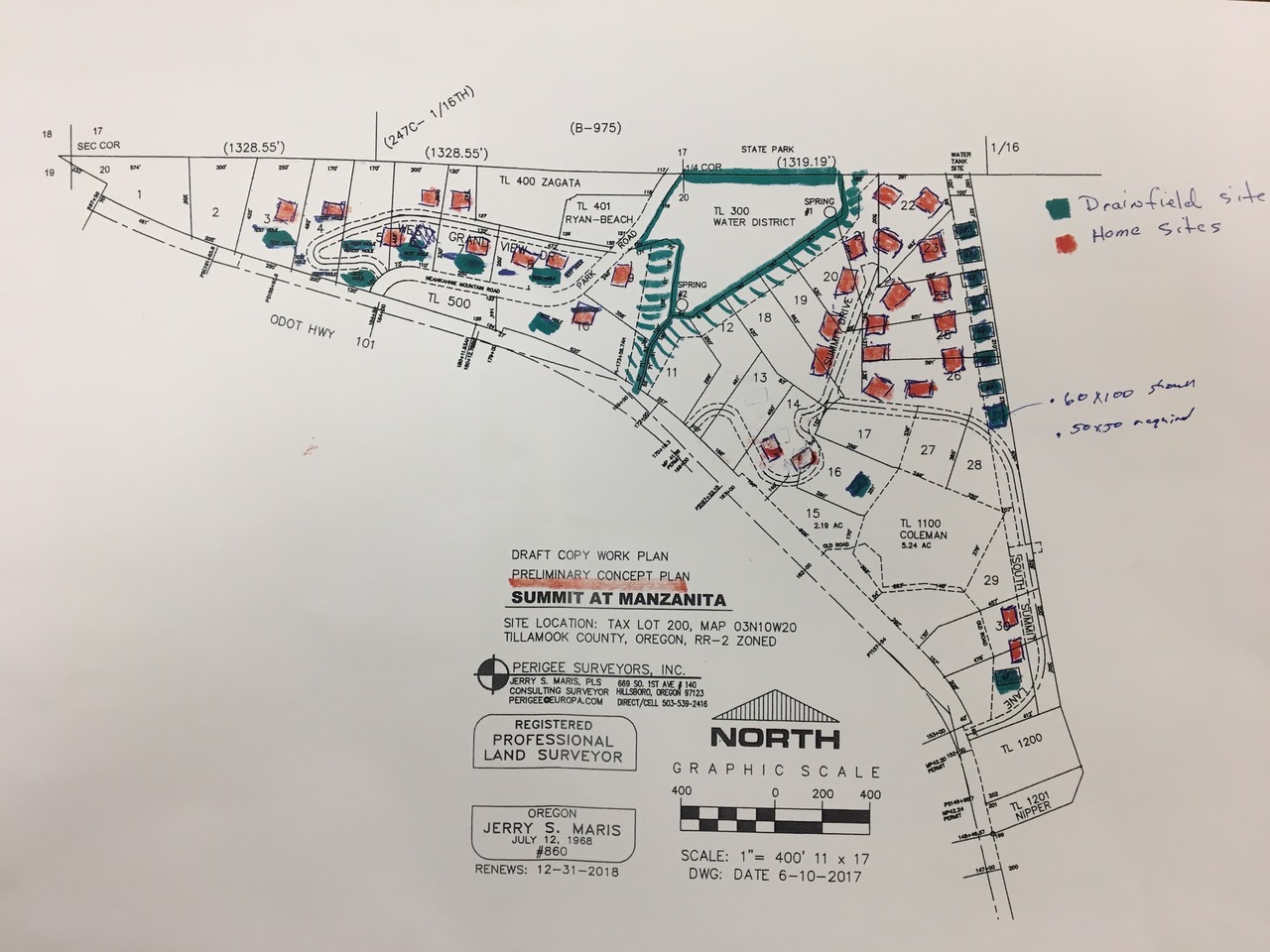
The first speaker, Jerry Maris, is the surveyor for the Summit at
Manzanita˛ development. Jerry shared the status of the Preliminary
Concept Plan˛ with the Board. Jerry emphasized the Preliminary
Concept˛ aspects of the plan in that fundamental work is continuing:
pausing in large part until the spring zone is better characterized by
the NWD hydrogeologist and that logging necessary to expose the more
eastern part of the parcel is continuing, weather permitting. One
certainty – the development will NOT exceed 30 housing sites given the
acreage and setbacks in the parcel. Another near certainty is that the
County/(state?) requirements for Rural˛ development is that
septic/drain fields will be used; not sewer.
The illustration below shows the current concept – two clustered
housing site areas, one west and one east of the Water District spring
area (marked in green lines with a 100 tree zone around it. Drain
fields are also shown in green though as green rectangles which are
large enough for two households. Everything subject to change as more
information is acquired.
The second speaker was Bob Long, principal consultant of CwM-H20, the
recently hired expert for the NWD. His scope of work is to assess both
the springs hydrology (#1 thru #3) as well as their vulnerability to
contamination, including a potential hazardous spill along Hwy 101.
He stated that his total work is about half-completed. His survey of
the scene has been completed and ‘most of the hydrology done’. He is
awaiting the 3-D, topographical łfine grain˛ mapping. (I believe that
this MIGHT be from DOGMI, state of Oregon). He is mentally testing
ideas around the Hwy 101 scenario. Will be pulling this all together
in the next weeks.
erry joined in, promoting the test holes are open and available for
study and interpretation. The holes are 6 feet deep; the County DEQ
staffer, Chris, must still come by and review and pass˛ each site;
always useful for sites to be evaluated by a qualified analyst; organic
soils 4 feet to 6 feet deep are visible; Tom Horning and DEQ people
must each review and evaluate each site ‹ and don’t know their
schedules.
Larry Kiser: Where and depth of spring zone?
Bob Long: Springs are of a low angle variety; are more considered an
“area” than point source; they create pipes thru a variety of means
over time tending to move horizontally. AND, delineation of
fracture zones and areas is hard to do. Can identify areas of
high, medium, and low flow areas around the springs (Roberts:
Sort of like a heat map yes).
ALSO, there are fracture flow˛ and flow thru basalts˛ in the
underlying geology. These are not visible from the surface; each test
site actually disturbs the ground, so don’t over do it; ancient
landslides and other events have churned the area. Interpretation requires experience.
My summary: So, there you have it – preliminary, on-going work; lots
of moving parts; more stable information will be made available when
its known. Everybody stating desire to be transparent, provide
visibility.